


Les Vosges

sameja
User
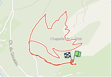

Length
2 km

Max alt
688 m

Uphill gradient
98 m
Km-Effort
3.3 km

Min alt
603 m

Downhill gradient
98 m
Boucle
Yes
Creation date :
2025-06-29 06:22:35.0
Updated on :
2025-06-29 12:57:50.058
2h35
Difficulty : Easy

FREE GPS app for hiking
 SityTrail
IGN / Geographical institutes
SityTrail Plus
The world is yours!
About
Trail Walking of 2 km to be discovered at Grand Est, Vosges, Le Ménil. This trail is proposed by sameja.
Description
Le circuit
Positioning
Country:
France
Region :
Grand Est
Department/Province :
Vosges
Municipality :
Le Ménil
Location:
Unknown
Start:(Dec)
Start:(UTM)
335946 ; 5308978 (32T) N.
Comments